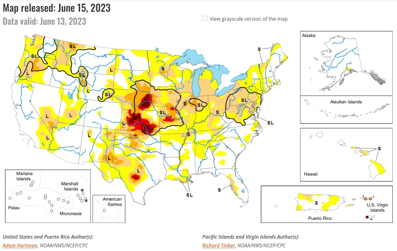
Above normal precipitation and below normal temperatures resulted in another week of targeted improvements across portions of the Intermountain West, adding to recent precipitation totals that have continued to improve long-term drought conditions. The exception is the Pacific Northwest, where below normal precipitation and above normal temperatures resulted in worsening drought conditions along the northern Cascades. There is a mix of improving and worsening drought conditions across the Great Plains. Improvements are mainly confined to the western Great Plains, where widespread 7-day rainfall totals exceeded 200 percent of average for the week, further adding to short-term precipitation surpluses.
Midwest: A storm system over the Midwest and Great Lakes over the weekend did little to halt widespread degradation of conditions across the Midwest. Although some locations did experience modest improvements, mainly in areas seeing in excess of 2 inches of rainfall, degradation to moderate drought (D1) and expansion of abnormal dryness (D0) is widespread across the Corn Belt, the Lower Peninsula of Michigan, and the Upper Midwest. High rates of evaporation from soils and vegetation over the past 1 to 2 months have resulted in large losses to soil moisture, with stream flows also dropping significantly across many of these same areas (falling below the 10th percentile of the historical distribution, particularly across the southern Great Lakes and the Corn Belt). There are many reports of browning and stressed vegetation, with several producers already resorting to supplemental feeding for their livestock due to reduced forage. Loss of yield remains a large concern for many.
High Plains: Although much of the High Plains region received above-normal precipitation this week, the region as a whole is a tale of 2 halves. Improvement to the drought depiction is warranted across western portions of the Central and Northern Plains, where 7-day precipitation totals exceeded 200 percent of average across most areas, adding to precipitation surpluses in recent weeks and improving long-term drought indicators. Conversely, deteriorating conditions are warranted across eastern parts of the High Plains region where heavy, convective rainfall was not enough to overcome predominantly near and above normal temperatures and high rates of evaporation from the soils and vegetation (known as evapotranspiration). For example, parts of South Dakota reported evapotranspiration rates from crops averaging around 0.25 inches per day, which varied slightly depending on the type of crop, essentially eliminating the effects of beneficial rainfall for several locations.


